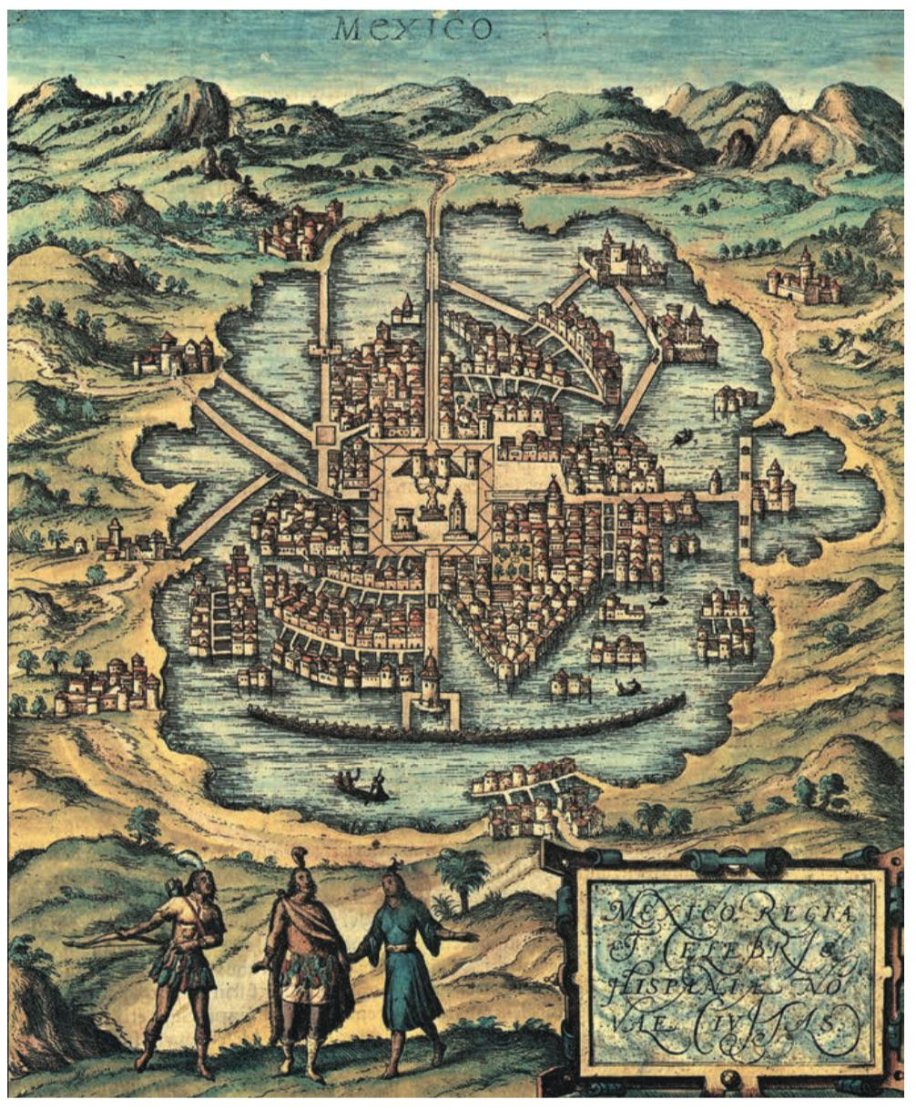
Historic(al) Map Porn
875 readers
1 users here now
Welcome to c/old_maps @ Mander.xyz!
A community about captivating historic and historical maps from around the world, from the oldest examples known to those created around 1950.
Notice Board
This is a work in progress, please don't mind the mess.
- 2023-06-13: We are looking for mods. Send a dm to @fossilesque@mander.xyz if interested!
About
Rules
- Don't throw mud. Be kind and remember the human.
- Keep it rooted (on topic).
- No spam.
Links
Similar Communities
Sister Communities
Science and Research
Biology and Life Sciences
- !anthropology@mander.xyz
- !microbiology@mander.xyz
- !biodiversity@mander.xyz
- !palaeoecology@mander.xyz
- !palaeontology@mander.xyz
Plants & Gardening
Physical Sciences
Humanities and Social Sciences
- !archaeology@mander.xyz
- !cooking@mander.xyz
- !folklore@mander.xyz
- !history@mander.xyz
- !old_maps@mander.xyz
Memes
founded 2 years ago
MODERATORS
1
2


8
7
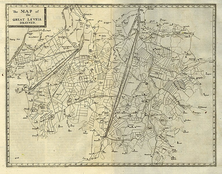
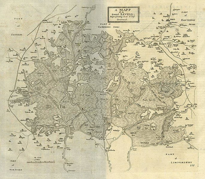
Context: https://www.elymuseum.org.uk/wp-content/uploads/2020/06/Drainage-who-drained-the-fens-1.pdf
A long time ago, the fens were watery marshes. They were wild, dangerous places filled with tall grasses and flat wetlands. There were also areas, or islands, of high land in the fens. Ely is sometimes known as The Isle of Ely because it was built on an island of solid ground surrounded by the marsh. Around 400 years ago, life changed dramatically when the fens were drained. The Dutch engineer Cornelius Vermuyden was asked by King Charles I to design a plan to turn the wetlands into farmland.
In 1630 the Old Bedford River was dug in a straight line from Earith to Denver, channelling the water from the fen towards the sea. The plans to drain the wetlands were paid for by a group of wealthy men, known as the 'Gentleman Adventurers', who were led by the Earl of Bedford. They were given acres of the new, drained farmland in return for their investment. They drained the fens by straightening meandering rivers, building embankments and sluices, a type of channel for water which is controlled by gates, to keep the tides out. They created washes to store the flood waters, such as the Ouse Wash reservoir which is the 3rd largest in England.
Local people, who relied on the wild fen for hunting and fishing, rebelled against the loss of their livelihoods. They smashed dams and destroyed dykes and became known as the 'Fen Tigers'. The process of draining the fens was very difficult because when the land was drained of water, the peat soil found in the fens shrank. Once the land in the fields were lower than the surrounding rivers, flooding became common for hundreds of years as water overflowed the new earth banks.
By the end of the 17th century, the fenlands looked totally different, with long straight channels and regular angles where wild wetlands and meandering streams had once been. Draining the fens took hundreds of years, and it is still an ongoing process today. The landscape is managed with drainage channels and pumps, which keep the water under control so that the rich peat soil can be used to grow a wide range of crops.
Source: Dugdale, William. The History of Imbanking and Drayning of Divers Fenns and Marshes: Both in Forein Parts, and in this Kingdom, and of the Improvement Thereby, Extracted from Records, Manuscripts, and Other Authentick Testimonies. United Kingdom, Warren, 1772. Second Edition. This work was first published in 1662.
The scan is from an ex-library book in a private collection. Full text can be found here: https://quod.lib.umich.edu/e/eebo/A36795.0001.001/1:4.30?rgn=div2%3Bview%3Dtoc
https://commons.wikimedia.org/wiki/File:%22The_Map_of_the_Great_Levell_drained%22_(1662).jpg
9
16
17

19

.jpg)
.jpg)
21
22
23
24
25
view more: next ›